They told me it was worth it. To go to the hassle of dropping my trailer in L.A. To go to the trouble of wiggling east, then back west to find Highway 1. To suck up a whole tank of fuel just for a hundred miles of roadway.
And they were right.
The legendary Pacific Coast Highway earned top marks from our intrepid traveling band for beauty, raw power, force of nature, and inspiration, and not necessarily in that order. I read somewhere that lots of people fly into San Francisco, rent a convertible, and drive the route north to south (the preferred direction). I agree. This was fun enough in a diesel truck, but how much more so in, oh, say, a ’97 Esprit Turbo. Highway 1 is built for sin.
This morning we said our tearful goodbyes to our foxhunting friends Kit and Greg and hit the road. We were inland for the first hour or so, then popped out on the coast at San Luis Obispo. (Cal Poly is located here.) The Hearst Castle passed on our right and a naval installation to our left.
Greg called just as we began to snake along the water; the marine layer was lifting, and sunshine danced on the water (aquamarine), seaweed/kelp (moss green) and rocks (salted white fading to mottled granite.) Greg said thanks to John for the custom designed thank you note he’d left, and he told us to make sure to watch for the sea lions. How on earth will we know if they’re there, I asked.
“You’ll know,” came the reply. Drivers will screech to a halt, he said, if some are spotted on one of the few sandy spits of beach. Not sixty seconds after we hung up, sure enough, a knot of cars loomed in a lay-by to our left, so we pulled over to join them.
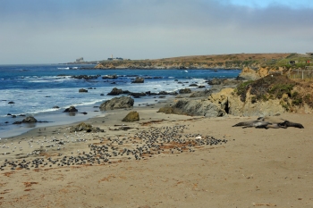
The surprise was they weren’t sea lions, but a pod of full-sized male elephant seals coming ashore at the Piedras Blancas Beach (just after San Simeon) for a sunbath and sand-roll. These mammoths are 1500-plus pounds (bigger than a horse), with cartoon-ish faces, a body designed by committee, and a voice that makes James Earl Jones sound like a soprano. If they weren’t so awe-inspiring they’d be laughable as they scooched ashore using part flipper pull, part snake-like slither. The ones that were already on the sand were alternately flipping sand onto their backs (or bellies, depending on the orientation) and lying idle. I did not see any of the smaller females, though several seals were play-fighting in the surf. (They looked like males, too.)
A little further on, we saw some smaller looking seals on top of one of the bigger rocks just outside the surf-line, so I wonder if that’s where the ladies congregate, leaving the theatrics to the boys. I tried some photos but knew they’d turn out as snapshots. The light was all wrong (midday) as was the perspective (mostly from above); we’re not invited to go down onto the beach and possibly harass the animals.)
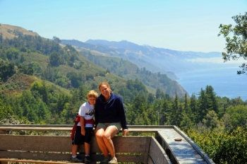
We drove on (it was barely fifty degrees and windy) and entered the majestic portion of the road where the pounding Pacific makes this one of the world’s best known driving routes. In terms of mind-blowing scenery, vertigo-inspiring drop-offs, quirky stop-offs, and that wind in your hair serendipity of anticipating what’s around the next bend, few routes can deliver like this one.
The Pacific Coast Highway was built in 1934 and took fifteen years to complete. It runs for nearly 550 miles along most of California’s coastline. But the crown jewel of the route is San Luis Obisbo to Monterey, the portion we traversed. It starts off pretty, but soon reels you in with splendor. As the coastal clouds lifted, it was truly like Oz was being revealed.
After the seals, we rolled through the idyllic forest-meets-ocean village of Cambria, then skirted the Julia Burns state park—granite cliffs dropping straight down to the pounding surf. We stopped at the well-regarded Nepenthe restaurant for lunch. It has a phoenix-eye view of the ocean 500 feet below. (There is a phoenix statue in the center of the outdoor dining area.) A Frank Lloyd Wright student designed the complex, and all the buildings appear to have grown from the cliffs. Lunch was good but the view was better, and the healing spirit of the place (a nepenthe is an elixir that has mystical powers to heal sorrows) best of all.
After Nepenthe, we continued north to Big Sur. While it is said that beatniks can no longer afford that enclave, the area retains much of the natural living and free loving vibes that made it famous. The road continues it’s winding route along the cliffs; many beaches are inaccessible, making them all the more enchanting, inspiring a rolling fantasy as miles pass and you imagine hiking down the cliffs and strolling along the sandy shore all but invisible to the world.
North of Big Sur you run through Carmel Highlands and Carmel by the Sea. (Clint Eastwood was mayor here 1986 to 1988.) We bypassed Monterey (figured the Baltimore Aquarium rivaled the one at Monterey, plus, wanted to get off the road) and headed east. Made it as far as Merced and stopped for the night. I needed a desk and Internet access to finish a story my editor wants for the newspaper this week, and John wanted a swimming pool. Beth wanted continental breakfast and an ice machine. Tonight, as well as today, we all got exactly what we wanted. And very likely, exactly what we needed.
Bonus Poll
At one point I said something aloud in the truck today (can’t remember what) and Beth exclaimed, “I was just thinking that! And that’s not the first time! We did that yesterday, too! You said something that I was just thinking! I think I’m becoming you! Or, maybe, you’re becoming me!”
From the back seat, I was deafened by the silence as John pondered the implications. He coughed softly. “John?” I asked. “You get a vote. Which would you rather have: your mom becoming me or me becoming your mom?”
More silence. He thought. Cleared his throat. Thought some more.
“Well,” he began. “It would be scary.” He paused. “It’d be scary if your personality ended up in mommy’s body.”
Beth and I howled with laughter. Still, I wonder if that was meant as complimentary or….
Any votes?
Bonus Notes on the Solvang/Santa Barbara Area
The Santa Ynez Valley region (home, naturally, to the Santa Ynez Valley Foxhounds, Monty Roberts and many other horses and horse farms) is also one of California’s biggest wine regions. the movie Sideways (that popularized Merlot) was filmed here. Many Californians consider Santa Barbara the best vestige of an early Golden State atmosphere. Dubbed the “American Riviera,” the city is toney and artsy at once, playing homage to California’s surf-and-sand lifestyle. The city’s walkability makes it a great destination for aimless wandering as you soak up the atmosphere. Mission Santa Barbara, founded in 1786, still functions as a church.
Shifting a half hour to the Big Oak Flat entrance to Yosemite National Park tomorrow morning. We’re to present ourselves at the Crane Flat campground by noon to try for a walk-in campsite. (Reservations were sold out six months ago for all campgrounds in the park.) I’m hopeful we’ll find something; if not, there are many places in the national forest that surround the National Park, or many private grounds outside. Not sure about Internet access, so this travelogue may go silent until Thursday evening, when we shift to a friend of Beth and Lenny’s in San Bernardino near L.A. (they’re racetrackers) to stay Thursday and Friday while we check out Los Angeles.
To be continued….
August 11, 2010
